 Tweet
Tweet
Originally posted by RC Vikings
View Post
-
So beautiful in your part of the country. I hope to get out there once in a while when my kid gets back. -
My pack arrives today. Bought an Osprey Atmos 65. I am going in Thursday night to one of the worst bear areas of the Sierra, but hiking through quickly. My plan is to hike over the 22 miles to meet my friends and then go on the 5 day trip with them, and then hike the 22 miles back, so it looks like I will be putting in an extra 44 miles, but it is better than 12 hours or driving. Still wondering if I could run it...
I am very excited.
Trying to put a map together of the route at the moment. Trying to get an idea of how many miles we will be doing, especially the cross county stuff that makes life difficult and slow, but is very rewarding.
https://mapsengine.google.com/map/ed...0.kn13hYqCseeILast edited by BigPiney; 08-05-2013, 02:17 PM. Reason: added map, of which I only know the route of the first 2 days and the last dayComment
-
Second annual guy's backpacking trip into the Trinity Alps was this weekend for Steelblue and I, along with another friend. This year we had our eyes set on Grizzly Lake which is not far as the crow flies from the Canyon Creek Lakes, where we went last year. However, it is basically inaccessible from the south due to the rugged terrain. There is another way to access it from the southwest, and is supposedly an amazing trail, but it is 18.5 miles each direction and we just didn't have that kind of time this year.
The northern route is much shorter at about 6 miles each direction. But it is a brutal 6 miles. The first mile goes straight up and over the Salmon Divide, covering 1,600 feet of elevation gain in a mile. You then immediately drop down the other side, descending the same elevation into the Grizzly Creek drainage.Then its a 4 miles slog up the canyon, ascending another 2,000 feet or so in that distance.
We all worked a half day on Friday, so we got a late start, hitting the trailhead at about 6:00pm. We ended up doing the last hour and half or so by headlight. We knew all of the good campsites were near the upper meadows, but we really had no idea where the meadows were in the dark. So we kind of stumbled around the last half hour, hoping that we might be able to recognize them when we saw them.
After seeing a couple of small campsites along the trail we wandered off-trail at one point across the creek and stumbled upon an amazing campsite set way off the trail.


Almost immediately after getting camp set up the deer started appearing in all directions. We had heard that they were not bashful in this area, but we had no idea how aggressive these suckers really were. They were drawn to the salt of our sweat like a moth to the flame. Our buddy that slept out under the stars had them sniffing his head all night and trying to steal all of his gear. They did make away with both of his hiking poles, dragging them 100 yards out into the meadow in order to chew up the leather straps.
When we set up camp, we figured we were close to the falls, but really didn't know how close until we woke up the next morning. Here is the view from my tent that I awoke to:

Grizzly Falls is the highest waterfall in the alps, initially free-falling about 100 feet, then cascading another 300-400 feet down the rocks until it settles under the massive rock pile at the base of the falls. It re-emerged right next to our camp, bubbling out of the ground to form Grizzly Creek. Pictures don't do this thing justice.


On Saturday morning, we left camp to climb up to Grizzly Lake. The trail up to the lake goes directly through a massive boulder field and is really hard to follow, especially as it heads up the steeper slopes of the rock wall. To call it a hike to the top would not be fair, as it is really a scramble to the top.
Our buddy and I decided to take an alternate route to the top, scrambling up a much steeper route than was the standard route most people take. It was really quite sketchy,as there was a couple of times when scrambling up where we ran out of good hand and foot holds and had to down-climb a short distance to find a different route. I doubt that my wife or my life insurance agent would have approved. There were several moments when the only thing between me and the rocks below was a small foot hold and about 400feet of very thin air. We eventually made it to the top to find Steelblue standing at the top of the waterfall.
Grizzly Lake was absolutely stunning, situated in a very deep granite cirque in the northern shadow of the highest mountain in the alps, Thompson Peak. It is fed by run-off directly from a glacier field on Thompson. There are a few campsites around the western edge of the lake, but getting your gear up would be no easy task. At about 170 feet depth, the lake is a deep, piercing blue that contrasted beautifully with the bright, white surrounding mountains and the deep blue sky overhead with billowing white clouds passing by.


After spending some time walking around the lake we headed up a gully on the side of the mountain toward a couple of saddles on the upper mountainous ridges. We had initially thought about trying to summit Thompson peak, but weren't sure which saddle would take us there most easily. We decided to head over the glacier to the northeast saddle. It was a tough slog over a huge boulder field to just reach the glacier. We spent some time there, refilling our water bottles directly from the snow melt before heading up the final push to the key-hole saddle at the top.

The view from the saddle was spectacular. We had an amazing view of the Canyon Creek Drainage and the alpine lakes that we hiked to last summer.

We could also see Mount Lassen about 130 miles to the east and Mt Shasta 50 or 60 miles to the north. We could also see that summiting Thompson Peak was going to be impossible from this spot without ropes and a lot more cajones that I possess.
We eventually worked our way over to the other saddle that we originally decided against, only to learn that it was clearly the route to take to summit Thompson peak. However, it was too late in the day to take on this new project, so headed back down the mountain after exploring a little and taking in the view to the southwest.
The hike out was grueling, but fairly uneventful. Grizzly Lake really is one of the best kept secrets on the west coast. Its difficult enough to reach that it keeps the masses away, yet it provides some of the most picturesque scenery and mountaintop vistas available anywhere.Comment
-
Nice trip.
If I can figure out how to post some pics, I will finally get around to writing my report as well.Comment
-
Thanks for the trip reports. Considering adding this to my backpacking "bucket list". However, with those elevation gains, I'll probably have to opt for the 18+ mile route rather than the 6 mile one. I'll have the time when I finally start on my bucket list.“Not the victory but the action. Not the goal but the game. In the deed the glory.”
"All things are measured against Nebraska." falafelComment
-
Awesome pics and a great report as always goose. I'll add a couple too.
When Goose and our buddy headed up the route close to the falls I knew better than to follow. Our friend is a pretty skilled climber and has a taste for a bit of danger. I followed a route that I thought was the main scramble, but I never saw a cairn until I got to the top. I had one sketchy section where I sent a few prayers to the heavens, but besides being strenuous it was mostly safe. I was very nervous when I got to the top and they weren't there yet. Both of them are in much better shape than me and I'd expected them to be waiting at the top. About 10 minutes passed before I saw them emerge at the top of the cliffs where there was a good 400-600 foot drop. I got this pic of them after they moved up a bit. Wish I'd taken it earlier as it looked like they were right on the edge.
image.jpg
I grabbed this shot just after I got to the top of the wall. It ended up being my favorite because it has Thompson Peak and the lake and falls.
image.jpg
Overall, this was one of the most beautiful places I've laid eyes on. The hike in and out was tough, but so worth it.Comment
-
Gorgeous.
Sent from my SCH-I535 using Tapatalk 2At least the Big Ten went after a big-time addition in Nebraska; the Pac-10 wanted a game so badly, it added Utah
-Berry Trammel, 12/3/10Comment
-
I've been waiting for your pics, let's get there! Here's how you do it from your phone, ER said it's even easier if you use tapatalk: (post #74)Originally posted by BigPiney View Post
http://www.cougarstadium.com/showthr...l=1#post984953Comment
-
So this trip was scheduled by some friends as a boys week out for one of them that went through a nasty divorce earlier this year. That is a story for another day. 3 weeks before the trip, I was invited, so I was all in. My wife, the saint, agreed, and so I bought a backpack that fits (finally) and get ready to head out into Kings Canyon National Park. This is some of the best parts of the High Sierra.
A little background; years ago as a 18 yr old I was an adult leader on a 50 miler where we spent a lot of time on the Middle Fork of the Kings River and specifically in Tehipite Valley. This is one of the most secluded places in the Sierra. Simply amazing.
The plan was for the trip to start around noon on Friday at Roads End in Kings Canyon. That is a 7 hour drive for me, or a 22 mile hike. I chose the hike. In retrospect, I probably should have driven, but nonetheless, those first 2 days were beautiful.
So I started, solo, on Thursday an hour from my house at about 2:15 in the afternoon. I knew I had to make 22 miles in the next 22 hours, so I went fast. Up and over Kearsarge pass.
Looking east from the pass.
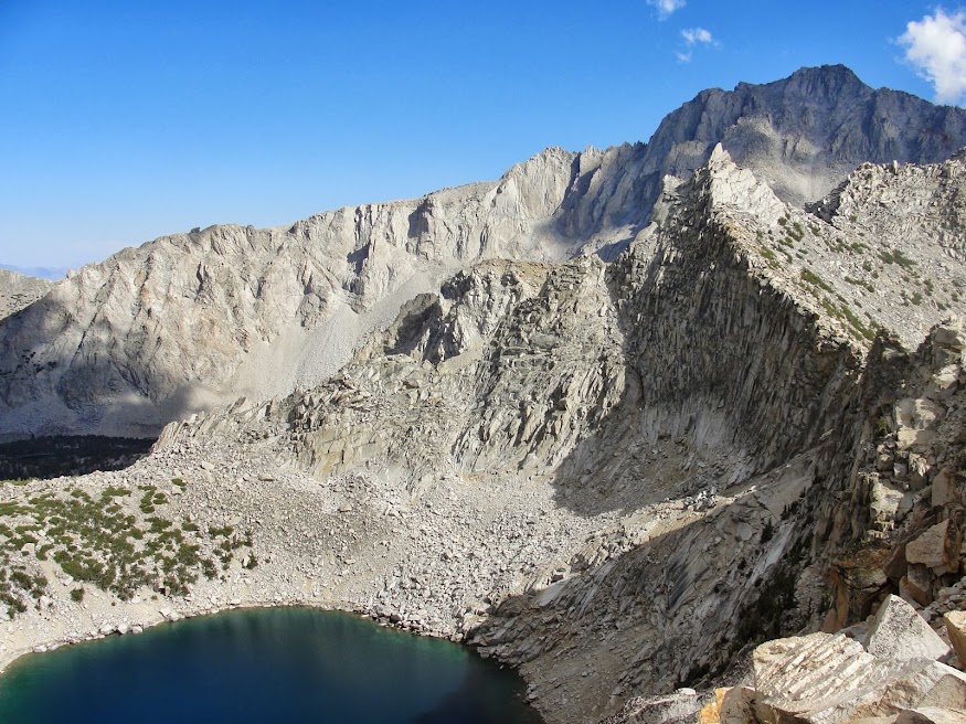 This is one of the best passes for getting into the high county) that evening, hit the pass around 4:30 (5 miles) and headed down hill past the Kearsarge Lakes and into the Bubbs Creek area.
This is looking west from the pass to the lakes and to my eventual campsite in the far canyon.
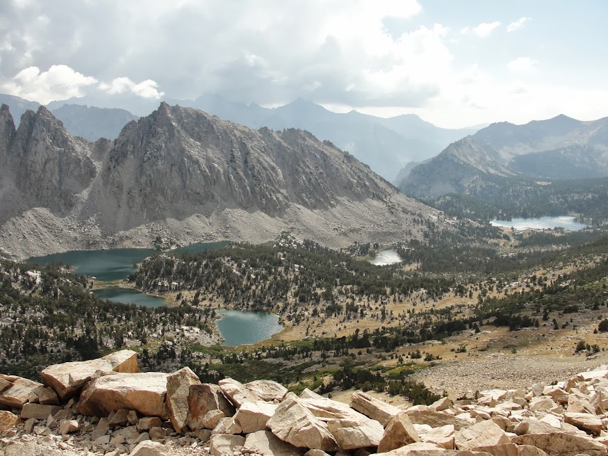 Hiked till about 8 pm and I estimate that I got 14 miles in that day.
Bubbs Creek:
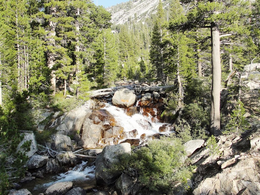 I should have stopped a mile earlier near another group where I could have shared a Bear Box, but I had a bear canister, so I trudged on to do it alone for the night. There are tons of bears in this area, so it was a bit of a restless night, but I and my food was left alone. Slept on a small tarp near the creek.

more later...Comment
-
-
I'm assuming that small black barrel-looking thing in the last photo is your bear canister? You just haul that along in your pack with your food, etc? Never seen that before - most folks I know just use a rope to hang a bag from a tree (sure - minor deterent for a bear.)Originally posted by BigPiney View PostComment
-
They fit nicely in a pack or can be strapped above (or below, I suppose). The bears in Yosemite are smarter than the average bear and can often figure out the rope thing, so bear canisters are required on back country hikes in that Park. I've heard some bears have even figured out how to open the canisters (one needs either a coin or a very strong fingernail).Originally posted by Eddie View PostComment
-
Wow. 22 mile hike or 7 hour drive? Those are the kinds of decisions that make me stay at home.Originally posted by BigPiney View Post"Nobody listens to Turtle."-TurtlesigpicComment
-
awesome.I'm your huckleberry.
"I love pulling the bone. Really though, what guy doesn't?" - CJFComment
-
Yes that is it. Like PAC said, it is also required for travel through the area that I was these days. I did ditch it in my friends car for the rest of the hike, but it is a necessary evil. We counter balanced the rest of the nights.Originally posted by Eddie View PostComment
Comment